
While Haivision mission-critical video wall solutions play a vital role in a joint operations center or mobile command center, the true power of critical intelligence is the software that informs mission planning and supports situational awareness. In a series of posts, we’re taking a closer look at the technology and software that our customers rely on every day in their operation and command centers.
For Haivision’s defense, government, and public safety customers, effective mission planning relies on fast, accurate intelligence and dynamic visualization. In the context of military and public safety operations, interactive and real-time data is critical when evaluating different mission scenarios. This is where cutting-edge technology from both Skyline Software Systems and Haivision can help support effective mission planning and execution through powerful, near real-time insights.
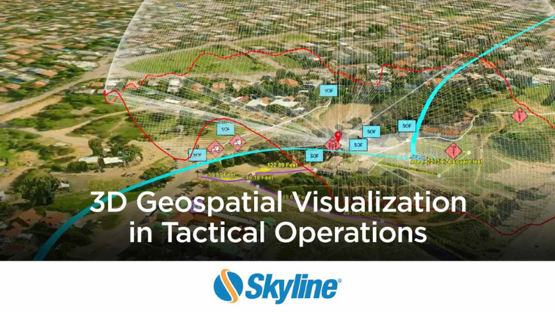
Skyline’s TerraExplorer solution is a cutting-edge 3D GIS (geographic information system) desktop viewer and creator that provides powerful tools and a high-resolution 3D environment to view, query, analyze and present geospatial data.

About Skyline and TerraExplorer
Much like Haivision’s mission to help our customers make informed decisions faster, Skyline is committed to helping customers get the right answers faster with cutting-edge 3D visualization technology using TerraExplorer’s advanced 3D geospatial capabilities.
A market leader in 3D earth visualization software and services, Skyline offers the applications, tools, and services that enable the creation and dissemination of interactive, photo-realistic 3D and Digital Twins environments tailored specifically to the needs of defense, public safety, and commercial sectors. Skyline works with a number of government agencies within the Department of Defense, including the United States Army and the United States Marine Corps, as well as federal agencies that oversee public safety.
The technology allows teams within these sectors to leverage Geographic Information Systems (GIS), which are powerful digital tools that capture, analyze, and visualize geographical data to understand patterns, relationships, and trends in the real world. In defense and military applications, GIS plays a crucial role by integrating geospatial data such as maps, satellite imagery, terrain data, and location-based information. It aids in planning and decision-making processes, enabling military personnel to assess terrain, plan routes, strategize deployments, and coordinate operations more effectively. GIS assists in identifying optimal locations for military installations, monitoring troop movements, analyzing threat patterns, managing logistics, and assessing the impact of various factors on mission success. In this way, GIS and Skyline’s TerraExplorer solution offers the ability for teams to gain situational awareness, maximize operational efficiency, and promote tactical effectiveness.
See Skyline TerraExplorer in Action
When planning a mission, TerraExplorer, combined with Haivision video wall technology, can provide near real-time actionable intelligence for mission planning. The technology allows users to layer new feeds onto existing data as they become available.
“Skyline gives the war fighter the ability to have as close to near real time data as humanly possible, especially with our mobile processing kits. We were now shaving not just hours, but sometimes days off getting this data to missions where it can be used,” explains Blair Jenkins, Director of Business Development, Skyline Software Systems.
However, real-time intelligence gained from the combined solution between Skyline’s TerraExplorer and Haivision’s video wall technology, Command 360, isn’t useful solely for mission planning.
The convergence of cutting-edge visualization technology has reshaped the possibilities for mission planning by providing one place for all intel, bringing all the data together for powerful, actionable intelligence. By marrying fast, accurate intelligence and dynamic visualization, more successful operations can be built, especially in defense and public safety applications.
While video walls elevate command center visualization capabilities, true critical intelligence is realized when both Haivision Command 360 and Skyline’s TerraExplorer solution are used in tandem. This combined solution not only facilitates the effective use of 3D geospatial data but also empowers mission planning, asset tracking, analysis, and other pivotal defense functions.


